
Just as we got to the Turoa ski field on the south western side of the mountain, it started raining/sleeting. After sitting inside for a bit it cleared up enough to head out onto the beginner slope, the only one open! Unfortunately all the snow that Helen saw up here last weekend has been obliterated by the warm northerly!
 After lasting a couple hours with Tim struggling to get used to kick turns and ascending slopes with the touring skis and getting throroughly wet, we headed down to Ohakune where we managed to dry off a bit in the sun before driving round to Whakapapa on the north west side of the mountain for the 1.5 hour walk up to the hut.
We arrived just before dark in very low visibility. The next morning however the skies had cleared and we headed out with fading starry skies and the sun rising from behind the now visible Pinnacle Ridge.

 Looking north from the hut.
 Looking back south at The Ruapehu Hut, cloud still hanging around on the upper reaches of the hill.

 Approaching the Pinnacles through the unopened ski field.
 Heading up the lower reaches of Number 2 Gully. A bit further on there was a distinctive smell of sulphur, a reminder of climbing on a still active volcanco (that is due an erruption).
 Looking across to the familiar conical Ngauruhoe (Mount Doom).
 After topping out the gully, we started traversing the narrow ridge up towards First Pinnacle. Looking back across to Second Pinnacle.


 As we descended the wind picked up, the rain started and we were pretty wet by the time we made it back down to the Cafe. First Pinnacle is the fourth pointy bit from the left. The rather bare-of-ice Pink Floyd Buttress on the far right.

 Looking north from the hut.
 Looking back south at The Ruapehu Hut, cloud still hanging around on the upper reaches of the hill.
 Approaching the Pinnacles through the unopened ski field.
 Heading up the lower reaches of Number 2 Gully. A bit further on there was a distinctive smell of sulphur, a reminder of climbing on a still active volcanco (that is due an erruption).
 Looking across to the familiar conical Ngauruhoe (Mount Doom).
 After topping out the gully, we started traversing the narrow ridge up towards First Pinnacle. Looking back across to Second Pinnacle.

 As we descended the wind picked up, the rain started and we were pretty wet by the time we made it back down to the Cafe. First Pinnacle is the fourth pointy bit from the left. The rather bare-of-ice Pink Floyd Buttress on the far right.
We've so far managed more winter climbing than you'd expect to get done in North Wales in a whole season and the season here hasn't really kicked off yet! Hope a bit more snow arrives before the ski fields are due to open properly in a few weeks.
 We left Wellington at 3am but slept the whole journey to Picton where we picked up Rob's car (who went with Helen to Ruapehu) and drove an hour and a half to St Arnaud, the entrance to the Nelson Lakes NP. The sky glowed orange behind us as we drove up one of the biggest wine producing areas in NZ heading west from Blenhiem and we made it to the waterfront at St Arnaud by 9:00.
 To save 3 hours of tramping Max had organised a water tax to the lake head. A great way to start off the trip.
 That still however left 7.5 hours of walking along the scenic Travers valley fully loaded before arriving at the Upper Travers hut just before dark. A popular summer trampers route who head over the Travers Saddle and back to St Arnaud via the Sabine Valley.
 Arriving at the hut and looking up at the East Face of Mount Travers. The next morning we went up to check out the obvious icefalls directly under the summit but they were out of condition.
 Looking back down the Travers valley from the hut
 Max under the South Face
 Sun rising over Mount Iris.
 We headed up a wide couloir and branched off a narrowing one heading up to the right. Snow conditions continued to give fantasic cramponing.
 After a few short icy steps as the couloir narrowed we finally had to get the rope out for a short crux section.
 The west ridge leading up to the summit of Kehu itself. Tappy (our original objective for the weekend is just visible on the horizon).
 View across to Travers while descending the NW slopes of Kehu on route back to the hut.
 Looking down the Travers valley on the way back to the hut.
 Leaving the hut for the walk back down Travers Valley. 'Table Couloir' is the leftward and narrowest heading up to the horizon.
  Back at the jetty at St Arnaud after a fantastic couple of days and a great way to start the winter! Soon to be continued up at the North Island Volcanoes.
 Sunrise at Blythe Hut
 Early morning view of Girdlestone (pointy peak on the right) and Tahurangi


 Ridge to Tahurangi -one for another day!


 The Brooklyn Wind Turbine on the way up Hawkins Hills
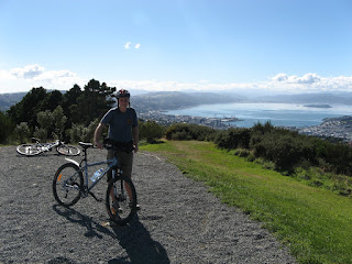 View from the Wind Turbine over Wellington harbour


 Look south over Wellington harbour
 Tim on the classic 'The Crack'
 Traversing Long Wall
 The strong northerly whipping the tops of the waves.